

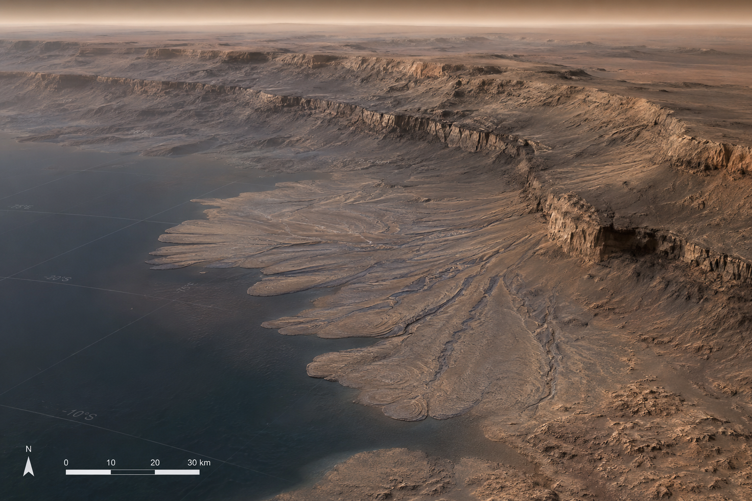
A new geological study of Mars’ Valles Marineris suggests that fan-shaped deposits in Southeast Coprates Chasma may record one of the highest ancient water levels identified on the planet. The research focuses on scarp-fronted deposits, a type of landform that can form where sediment carried by flowing water enters a standing body of water such as a lake, sea, or large paleolake.
The study examined the promontory region of Southeast Coprates Chasma using orbital imagery and digital elevation models from CTX, HiRISE, CaSSIS, HRSC, and MOLA datasets. The researchers found networks of branched channels, scree deposits, exposed bedrock, and fan-shaped landforms that together point to a past environment shaped by flowing water and sediment transport.
A Possible Shoreline in Valles Marineris
Valles Marineris is the largest canyon system on Mars, stretching thousands of kilometres across the planet’s surface. Within this vast system, Coprates Chasma forms one of the major connected troughs. The new study focuses on the southeastern part of Coprates Chasma, where a mountain-like promontory borders the Valles Marineris Depression.
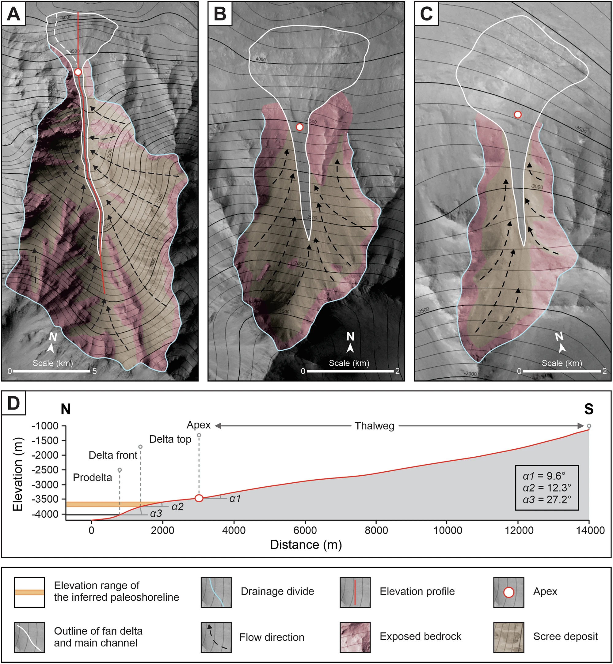
At the downstream ends of several drainage basins, the team identified scarp-fronted deposits. These deposits have a fan-shaped surface, a clear apex where sediment appears to spread outward, and a steep front marking a distinct change in slope. The researchers interpret this break in slope as the boundary between a delta top and delta front, which can preserve the level of an ancient shoreline.
What the Deposits Reveal
The study reports three main scarp-fronted deposits in the promontory region. Their surfaces spread radially from upstream valleys and terminate in steep fronts at roughly similar elevations. This geometry is important because it differs from a simple dry alluvial fan and is more consistent with a fan delta formed at the edge of standing water.
The researchers found that the key deposits occur within an elevation range of about -3750 to -3650 metres. In the study’s interpretation, this range marks a paleoshoreline, or the former margin of a large body of water. The team also identified similar landforms along connected regions toward Capri Chasma, Chryse Chaos, and Hydraotes Chaos, suggesting that the same water-level signal may extend beyond the local study area.
Evidence for Flowing Water
The promontory contains multiple drainage basins with V-shaped valley profiles and branched channel networks. These features are commonly associated with fluvial erosion, where flowing water cuts into bedrock and transports sediment downslope.
The study also identifies exposed bedrock along drainage divides and smoother scree deposits on slopes between the ridges and valley floors. In the proposed source-to-sink model, sediment was generated by weathering and mass wasting, temporarily stored on slopes, then moved by water through channels toward the basin outlets.
- Branched channels indicate organised drainage through the promontory.
- Scree deposits suggest sediment supply from weathered bedrock slopes.
- Fan-shaped deposits show radial spreading at basin outlets.
- Breaks in slope mark the possible transition from delta top to delta front.
Desiccation Cracks and Dune Ripples
High-resolution HiRISE and CaSSIS images also show surface textures on one of the fan-shaped deposits. The study reports dune ripples, desiccation cracks, scree material, and exposed bedrock. Desiccation cracks are especially relevant because they can form when wet sediment dries out, although the study interprets them within the broader context of the landform and elevation data rather than as standalone proof of water.
The presence of dune ripples over some older surface features suggests that after the water level dropped, wind-driven activity became more dominant. This fits with a broader transition from a wetter or more water-active phase of Mars toward the colder and drier conditions that dominate the planet today.
When Did This Water Highstand Occur?
The researchers link the inferred water-level highstand to the boundary between the Late Hesperian and Early Amazonian, around 3.37 billion years ago. In the study’s interpretation, this period may represent a time when surface water availability on Mars was unusually high compared with later stages of the planet’s evolution.
After this highstand, the water level likely fell. The study suggests that later incision into the delta-top deposits may have occurred as the standing water body receded. Over time, eolian activity then modified and partly buried some of the older water-related features.
Why This Matters for Mars Habitability
Ancient water-lain deposits are important because they help reconstruct the environmental history of Mars. If a standing body of water existed across parts of Valles Marineris and connected regions, it would provide boundary conditions for understanding where sediments accumulated above and below water.
This matters for astrobiology because sedimentary environments can preserve chemical and physical traces of past conditions. The study does not claim evidence of life. Instead, it identifies geological settings that may help guide future searches for biosignatures, if such evidence exists on Mars.
What Remains Uncertain
The findings are based on geomorphological interpretation, orbital imaging, and elevation analysis. While the evidence supports a fan-delta and paleoshoreline interpretation, some regional deposits lack the same level of high-resolution elevation data available for the main study site. This means the broader extent of the inferred shoreline remains an interpretation that can be tested with future datasets.
The research adds another piece to the long-running scientific effort to understand when, where, and how liquid water shaped Mars. By connecting local fan-delta deposits in Southeast Coprates Chasma with similar features across Valles Marineris and nearby chaotic terrains, the study strengthens the case that Mars once hosted large-scale standing water environments during a key period in its geological history.